


Southern Indiana Business Report
INDIANAPOLIS — The Indiana General Assembly approved the new congressional and state legislative district lines Oct. 1, concluding the body’s constitutional duty of redistricting. Indiana is required by state and federal law to redraw Statehouse and congressional maps following the nationwide census every 10 years.
“We have said all along that we were committed to drawing fair maps in a transparent way, and I believe we have done that,” Senate President Pro Tem Rodric Bray, R-Martinsville, said. “We prioritized keeping communities of interest together and drawing districts that make sense for the Hoosiers who live there, while maintaining nearly equal populations in each district. I believe these maps reflect feedback from the public and will serve Hoosiers well for the next decade.”
“We’re incredibly grateful for the work of Rep. Greg Steuerwald and Sen. Eric Koch who tirelessly and thoughtfully led the way on drawing these maps,” House Speaker Todd Huston, R-Fishers, said. “Redistricting is a complex and important process that impacts all Hoosiers. We’re thankful for the hundreds of constituents who shared their feedback along the way, and I’m confident we delivered fair maps that ensure every Hoosier vote counts.”
Huston and Bray both emphasized the new maps meet all state and federal requirements, and focus on maintaining compactness and keeping communities of interest together.
In early August, legislators hosted public meetings in Indiana’s nine congressional districts to gather feedback from the public on Indiana’s redistricting process. The Senate and House elections committees also held a total of three public hearings on HEA 1581, which contains the maps, as the legislative process played out in September. In total, more than 18 hours of public discussions were held on the maps and legislators heard from more than 200 members of the public.
House Enrolled Act 1581 now moves to Gov. Eric Holcomb’s desk for consideration as a new law. If signed, these are the districts candidates will run in for the 2022 election.
Highlights of the new plan
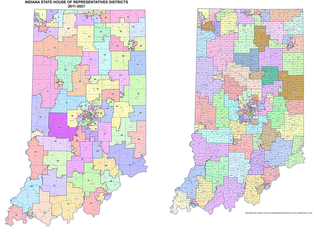
The Indiana House map increases the number of counties that are wholly contained within one House district from 26 to 32. There are 22 fewer township splits where a single township is represented by multiple House districts. The House map includes a less than 1% deviation from the ideal population of 67,855 for each district.
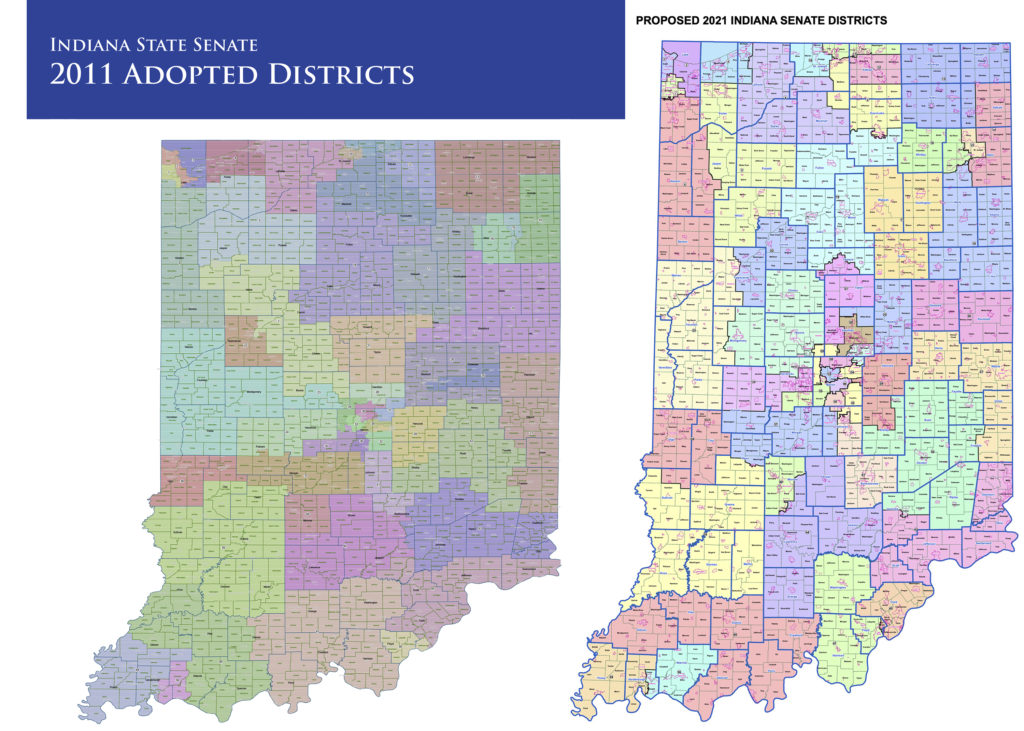
The Senate map increases the number of whole counties contained in one Senate district from 49 to 65, keeps 96% of all townships whole and keeps 92% of all cities and towns whole.
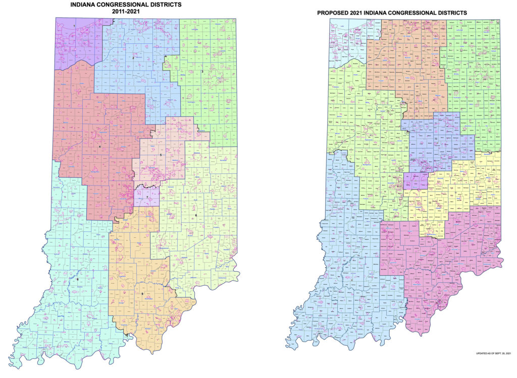
The congressional map keeps 84 of Indiana’s 92 counties whole, and includes a near equal deviation, one or fewer persons, from the ideal population of 753,948.
Implications for the region
Congressional changes
The only impact of the congressional map change for the region would be the move of Orange and Crawford counties from the Ninth District (Rep. Trey Hollingsworth, R-Jeffersonville) into the Eighth District (Rep. Larry Buschon, R-Newburgh). Under the map now in use, western portions of Crawford County are already in the Eighth District. The change would see the entire county move there. Greene, Daviess, Martin and Dubois counties would remain in the Eighth District. Lawrence and Washington counties would remain in the Ninth District.
Indiana Senate
Greene County
Greene County would see no changes, remaining entirely within District 39 (Sen. Eric Bassler, R-Shelburn).
Daviess County
Daviess County would not see any changes, remaining entirely within District 39 (Sen. Eric Bassler, R-Shelburn).
Martin County
Martin County would see no changes, remaining entirely within District 39 (Sen. Eric Bassler, R-Shelburn).
Dubois County
Dubois County would go from being split between two districts to being entirely within one district. Boone, Madison, Bainbridge, Patoka and Cass townships would remain in District 48 (Sen. Mark Messmer, R-Jasper). Harbison, Columbia, Marion, Hall, Jackson, Jefferson and Ferdinand townships would move from District 47 (Sen. Erin Houchin, R-Salem) to District 48 (Sen. Mark Messmer, R-Jasper).
Lawrence County
Lawrence County would see no changes, remaining entirely within District 44 (Sen. Eric Koch, R-Bedford).
Orange County
Orange County would remain entirely within one district but would see that district change. The plan would move the county from District 47 (Sen. Erin Houchin, R-Salem) to District 44 (Sen. Eric Koch, R-Bedford).
Crawford County
Crawford County would remain in a single district but would see that district change. The plan would move the county from District 47 (Sen. Erin Houchin, R-Salem) to District 48 (Sen. Mark Messmer, R-Jasper).
Washington County
Washington County would not see any changes, remaining entirely within District 47 (Sen. Erin Houchin, R-Salem).
Indiana House
Greene County
The proposed plan would see all of Greene County in a single district. The portions of Greene County currently in District 62 (Rep. Jeff Ellington, R-Bloomington) — Smith, Jefferson, Highland, Beech Creek, Stockton, Grant, Fairplay, Richland, Center, Stafford, Washington, Cass, Taylor and Jackson townships — would move to District 45 (Rep. Bruce Borders, R-Jasonville) to join Wright Township — the home of Jasonville.
Daviess County
Daviess County would go from being split among three districts under the current map to being split between two districts. Most of the county would not see a change at all. Bogard, Van Buren, Washington, Barr, Veale, Harrison and Reeve townships would remain in District 63 (Rep. Shane Lindauer, R-Jasper). Steele Township, which is currently in District 45 (Rep. Bruce Borders, R-Jasonville), would move into District 63 (Rep. Shane Lindauer, R-Jasper). Elmore Township, which is currently in District 62 (Rep. Jeff Ellington, R-Bloomington), would move to District 45 (Rep. Bruce Borders, R-Jasonville). Madison Township, which is currently split between District 62 (Rep. Jeff Ellington, R-Bloomington) in the north and District 63 (Rep. Shane Lindauer, R-Jasper) in the south, would move into District 45 (Rep. Bruce Borders, R-Jasonville).
Martin County
The proposed move would put all of Martin County into a single district. Perry and Center townships, which are currently split between District 62 (Rep. Jeff Ellington, R-Bloomington) in the north and District 63 (Rep. Shane Lindauer, R-Jasper) in the south, would move, along with Mitchelltree Township, into District 63 (Rep. Shane Lindauer, R-Jasper). The remaining portions of Perry and Center townships, along with all of Halbert, Rutherford and Lost River townships, would stay unchanged in District 63 (Rep. Shane Lindauer, R-Jasper).
Dubois County
Dubois County would remain split between two districts, but there would be some minor changes in which parts of the county are in which district. Boone, Harbison, Madison, Bainbridge and Marion townships would remain in District 63 (Rep. Shane Lindauer, R-Jasper). Jackson, Jefferson and Ferdinand townships would remain in District 74 (Rep. Stephen Bartels, R-Eckerty). Columbia and Hall townships would move from District 63 (Rep. Shane Lindauer, R-Jasper) into District 74 (Rep. Stephen Bartels, R-Eckerty). Patoka and Cass townships would be split. Whereas both townships are currently in District 74 (Rep. Stephen Bartels, R-Eckerty), the new arrangement would see the western portions of both townships move into District 63 (Rep. Shane Lindauer, R-Jasper) while their eastern portions would remain in District 74 (Rep. Stephen Bartels, R-Eckerty).
Lawrence County
Lawrence County would go from being split between two districts to being entirely within one district. Perry, Marshall, Pleasant Run, Indian Creek, Shawswick, Guthrie and Spice Valley townships would remain in District 65 (Chris May, R-Bedford). Marion Township, which is currently split between District 65 (Chris May, R-Bedford) in the north and District 73 (the late Steve Davisson, R-Salem) in the south, would move into District 65 (Chris May, R-Bedford). Bono Township, which is currently in District 73 (the late Steve Davisson, R-Salem), would also move into District 65 (Chris May, R-Bedford).
Orange County
Orange County would remain split between two districts but with some major changes. Northwest, Orangeville, Orleans, Northeast, Paoli and Stampers Creek townships would move from District 73 (the late Steve Davisson, R-Salem) to District 65 (Chris May, R-Bedford). Jackson and Greenfield townships would remain in District 74 (Rep. Stephen Bartels, R-Eckerty). French Lick and Southeast townships would move from District 74 (Rep. Stephen Bartels, R-Eckerty) to District 65 (Chris May, R-Bedford).
Crawford County
Crawford County would see no changes and would remain entirely in District 74 (Rep. Stephen Bartels, R-Eckerty).
Washington County
Washington County would see the most dramatic changes in the region, including going from being entirely within one district to being split among three districts. Brown, Jefferson, Vernon and Madison townships would go from being in District 73 (the late Steve Davisson, R-Salem) to District 65 (Chris May, R-Bedford). Monroe, Gibson, Washington and Franklin townships would move from District 73 (the late Steve Davisson, R-Salem) to District 69 (Rep. Jim Lucas, R-Seymour). Howard, Pierce, Polk, Posey and Jackson townships would move from District 73 (the late Steve Davisson, R-Salem) to District 70 (Rep. Karen Engleman, R-Depauw).
More detailed maps and further information on redistricting can be found here.