Carol Johnson, Southern Indiana Business Report
The Federal Highway Administration and the Indiana Department of Transportation have issued a Tier 1 Combined Final Environmental Impact Statement/Record of Decision (FEIS/ROD) for the Mid-States Corridor Study.
The document includes changes to the Draft Environmental Impact Statement (DEIS) based on agency and public input. The FEIS/ROD is now available for public viewing at several libraries and public locations.
The Tier 1 Study of an improved highway connection in southern Indiana is a product of the partnership of the Mid-States Corridor Regional Development Authority and INDOT.
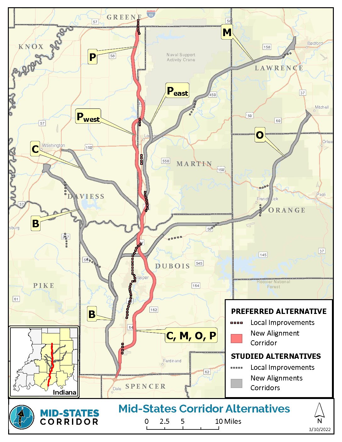
Initially, several routes were considered. In April 2022, INDOT announced that Route P was preliminarily selected as the route the project would follow. Route P extends 54 miles and generally follows US 231 north from I-64, bypassing Jasper and Huntingburg to the east and Loogootee to the west, ending at the I-69/US 231 interchange.
The planned roadway would run from Spencer County to Martin County. The stated goal of the route is to improve transportation in the southern part of the state, but critics have voiced opposition to the project for its negative impact on homeowners who will be dislocated and the environment.
Dubois County, which includes Jasper and Haysville, is among the counties along the proposed Mid-States Corridor.
“Dubois Strong recognizes the need for Dubois County and Southwestern Indiana to continue to improve the access and connectivity available for its citizens and businesses,” said Ed Cole, executive director of Dubois Strong, the county’s economic development organization. “Dubois Strong believes that the conclusion of the Tier 1 Study and the issuance by the Indiana Department of Transportation of the FEIS/ROD is confirmation that there is a need for this improved highway connection, and looks forward to the next steps as this project continues to move forward with the support of local citizens, businesses and government agencies.”
Several routes were considered and public meetings were held before INDOT and the Mid-States Corridor Regional Development Authority announced the selection of alternative P in 2022.
Concerns about loss of housing
One of the criticisms has been that the route will take motorists around small towns, which will hurt the business communities.
Currently, the preferred route would bypass Loogootee and remove about two dozen houses from the city, both are concerns for Loogootee Mayor Noel Harty.

“I’m not oblivious to the fact that everybody is in a housing crunch but here in Loogootee we have next to nothing available ever,” Harty said. “The fact it’s going to bypass the city and will take out 20 or 25 houses is a real concern for me.”
With a population of less than 3,000, Harty said businesses rely on travelers who pass through and stop for gas, a meal or to shop.
Harty acknowledged there could be benefits, such as an exit that would take travelers to West Boggs Park, a popular campground and lake in Daviess-Martin counties, and he understands it could be a plus to the overall region.
“For Boggs, it might be a positive if there’s an exit taking you to the park, but to take away any number of houses is a concern,” Harty said.
The FEIS addresses property relocation and number of parcels affected, which varies among the proposed routes.
“Relocation impacts from a transportation facility of this size and type are expected to be large and complex. They will occur along the entire project corridor. Although the more developed areas such as around Jasper, Huntingburg, Bedford and Loogootee would be expected to have a greater potential to impact residences and businesses, the summation of impacts to rural areas can be as substantial as urban areas,” read the report.
In the document, potential relocations were separated into categories: agricultural, business, institutions (churches, schools and libraries) and residential. For instance, regarding the route identified as Refined Preferred Alternative P, the number of total relocations ranged from 114 to 156. Housing would make up the bulk of the relocations, estimated between 75-108.
What’s next?
With the selection of Refined Preferred Alternative P, INDOT is following department processes for proceeding with the Tier 2 studies. Procedures include reviewing section priority before determining a timeline for the next phase of study.
The study says Tier 2 would finalize decisions on location and design, which could take years.
The FEIS/ROD is available for viewing online at https://midstatescorridor.com/feis/ and at libraries and other public locations listed on the website.
The Mid-States Corridor Study is a tiered environmental document consistent with the guidance established by the Council of Environmental Quality (CEQ) under the National Environmental Policy Act (NEPA) and conforming to processes developed by FHWA and INDOT. Tiering separates the broader issues, such as selection of the general location and mode choice in Tier 1, from the more detailed site-specific impacts in Tier 2.
The FEIS/ROD includes updates to the Tier 1 DEIS. Responses to public and agency comments received on the Tier 1 DEIS are located in Volume IV of the FEIS/ROD.


